

UPDATE[8/9/24. 2:30PM]

Tornado chances have decreased for our area, though they remain possible. Some of the conditions around Avalon have made severe storms less likely this afternoon. Wind gusts remain likely, but heavy thunderstorms, torrential downpours, and tornados are looking more hit or miss. Whatever happens, conditions are expected to improve for the weekend.
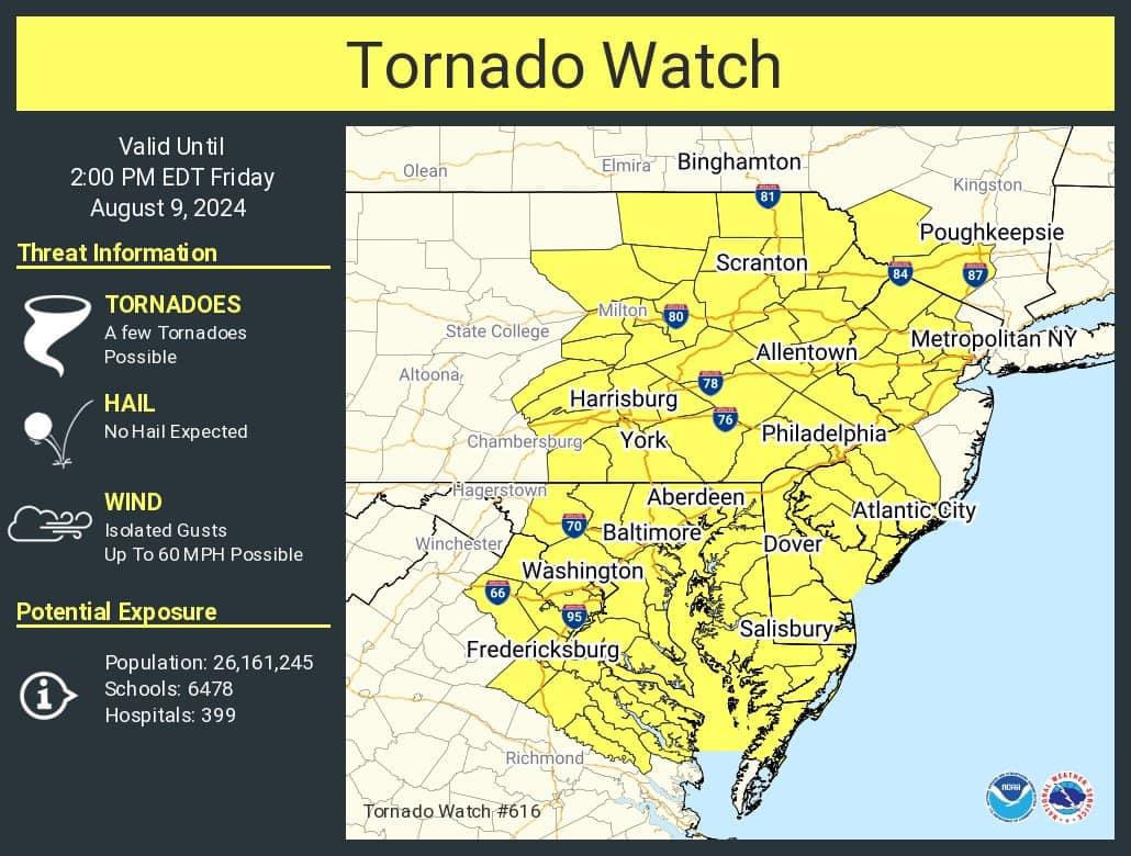
UPDATE [8/9/24. 6:45AM]
A Tornado Watch has now been issued for our area through 2pm. This does not mean that tornadoes will definitely occur, just that conditions are favorable for them to develop.
UPDATE [8/8/24. 5PM]
A Wind Advisory has been added for our area from 6am to 11pm Friday, predicting winds of 15 to 25mph with gusts up to 50mph during that time. Residents are advised to secure loose objects in their yards or on their decks and balconies.
Additionally, it looks like the threat for tornados on Friday has ticked up a bit, though it still remains fairly low.
UPDATE [8/8/24. 9:30AM]
As of this morning, there have been some slight changes to the forecast for the remnants of Hurricane Debby as they move through our region.
A Small Craft Advisory is in effect from 5pm Thursday through 6am Friday due to elevated winds and gusts as a result of the storm. Additionally, the Gale Watch has been upgraded to a Gale Warning, in effect from 6am Friday through 6am Saturday, as we are expecting wind of 20 to 30 knots with gusts up to 40 knots during that time frame and seas of 6 to 9 feet. A high rip current risk exists from 8am Friday through 8pm the same day, though they are still possible outside of that time frame.
The risk of excessive rainfall totals and flash flooding has been reduced for our area, with the bulk of that type of weather now expected to occur along I-95 and locations to the north and west, though it is still possible that we could see some heavy downpours, especially later on Friday and very early on Saturday morning, with the system potentially clearing out for Saturday. The storms more westerly track does put us on the side that is more prone to severe thunderstorms with a slightly elevated risk of tornados, so be alert during this time period. Tidal flooding is not expected to be a concern at this time.
Maps by the National Weather Service and National Oceanic Atmospheric Organization are below, as are up-to-date videos by local weather organization NorCast Weather and local meteorologist Joe Martucci, who you may recognize from his appearances and presentations at the library. These will be replaced with the latest from each as they become available through Friday.


UPDATE [8/7/24. 9:30AM] The storm is now predicted to arrive in and move through our area faster than originally expected, as well as further to the West. This means that the total rainfall that we can expect will likely be on the lower end of the original predictions, though still potentially quite substantial. Additionally, according to NorEaster Nick, since this puts us on the Eastern side of the system, it does increase our risk of severe storms and even tornadic activity, though the latter still probably remains unlikely. On the plus side, if this forecast holds, we can expect everything to wrap up by Saturday morning, allowing us to enjoy pleasant weather for the rest of the weekend.
ORIGINAL ARTICLE:
Hurricane Debby made landfall in Florida early on Monday and is now expected to slow down as it makes its way across the state and into the Atlantic Ocean. While it has now weakened to a Tropical Storm, it is possible that it may strengthen back to a Category 1 Hurricane once it is over the water again. It will then likely linger off the coast of Georgia and the Carolinas before coming ashore once more in one of those states.
While it is still down South, it will funnel tropical moisture into a front that moves through our area this week, allowing for heavier downpours to enter the region. It is then expected to move north and potentially pass directly over Southern New Jersey. Depending on the exact track and timing that the storm takes, we could wind up seeing rainfall totals of 6″ or more on Friday and Saturday. When added to the potential rainfall midweek this could see our area doubling our usual August monthly rainfall in just a matter of days, which would lead to flooding issues throughout the state. High surf, tidal flooding, and wind gusts of up to 40mph, especially along the coast, are also possible.
It should be noted that while the storm is very likely to head through our community, the exact effects are very hard to predict this far in advance. We will update this article as more information becomes available.


